
North West Ireland Tourism
Visitor Guide to Mayo, Sligo, Donegal, Roscommon, Leitrim, Cavan & Monaghan
Visitor Guide to Mayo, Sligo, Donegal, Roscommon, Leitrim, Cavan & Monaghan
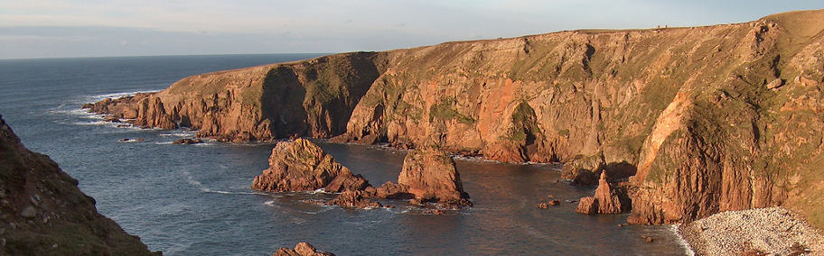
Bloody Foreland
| 0-9 A B C D E F G H I J K L M N O P Q R S T U V W X Y Z |
Bloody Foreland
Bloody Foreland or “Cnoc Fola” (The Hill of Blood) derives its name from the evening sun which illuminates the rocks along this section of the coast to a rich red hue. In the autumn months, too, a thick covering of fern enflames the hillside with a russet-red-brown colouring. Bloody Foreland has no background in factual history to warrant the title “bloody”, although folklore records that one particularly unlikable warlord “Balor of the Evil Eye” was eventually slain by his grandson Lugh Lámh Fhada on the slopes of Cnoc Fola. Indeed, some say that the tide of blood which flowed from Balor’s evil eye stained the hillside and gave it its name.
But whatever its origin Bloody Foreland is seriously impressive, and the vistas from it to Árainn Mór, Gabhla, Tory Island, and Horn Head, are quite remarkable. Indeed these great panoramas are, in themselves, ample reward for visiting. The Bloody Foreland coastal path, too, reveals stunning views with every fold in the cliff face, surprising us with sea stacks, inhospitable coves, shear faces, and always with the incessant booming of waves crashing on the rocks far below. Look out too for seabird populations of all kinds, from kittiwakes, to gannets, and puffins. Look out for evidence of seals, and dolphins, and further offshore, for brief appearances by whales.
Bloody Foreland is predominantly an Irish speaking region and this proclivity is reflected everywhere, from the place names, to the directional signage, and the business names in the nearby villages. And we wonder about the times of old, and the rugged people who farmed this exposed place, calling their greetings in Irish, and every greeting ending with a religious addendum of blessing.
Bloody Foreland is a beautiful and inspiring spot, and one of the great coastal walks of North Donegal.
Book Bloody Foreland Accommodation
But whatever its origin Bloody Foreland is seriously impressive, and the vistas from it to Árainn Mór, Gabhla, Tory Island, and Horn Head, are quite remarkable. Indeed these great panoramas are, in themselves, ample reward for visiting. The Bloody Foreland coastal path, too, reveals stunning views with every fold in the cliff face, surprising us with sea stacks, inhospitable coves, shear faces, and always with the incessant booming of waves crashing on the rocks far below. Look out too for seabird populations of all kinds, from kittiwakes, to gannets, and puffins. Look out for evidence of seals, and dolphins, and further offshore, for brief appearances by whales.
Bloody Foreland is predominantly an Irish speaking region and this proclivity is reflected everywhere, from the place names, to the directional signage, and the business names in the nearby villages. And we wonder about the times of old, and the rugged people who farmed this exposed place, calling their greetings in Irish, and every greeting ending with a religious addendum of blessing.
Bloody Foreland is a beautiful and inspiring spot, and one of the great coastal walks of North Donegal.
How to get to Bloody Foreland
By car. Follow the N56 west from Letterkenny to Gortnahork, and follow local roads and signage to Bloody Foreland.Where to stay near Bloody Foreland
Bloody Foreland has a wide range of nice places to stay including hotels, self-catering holiday homes, guesthouses and B&B's.Book Bloody Foreland Accommodation
Explore more
Bloody Foreland is surrounded by beautiful coastal towns. Don't miss Falcarragh and Dunfanaghy if you are travelling east, and Bunbeg and Kincasslagh if travelling south.Things to do in Bloody Foreland
- Explore wonderful Mount Errigal, the 2nd highest mountain in Ulster and the highest on Co. Donegal at 752m. A steep climb to the summit begins from a lay by off the road to Letterkenny about 5 Kms from Dunlewey. Enjoy!
- Glenveagh National Park lies in the heart of the Derryveagh Mountains in the north-west of Co. Donegal. It is a remote and hauntingly beautiful wilderness of rugged mountains and pristine lakes. The Park, over 16,000 hectares in extent consists of three areas. The largest of these is the former Glenveagh Estate, including most of the Derryveagh Mountains. To the west are the quartzite hills around Crocknafarragh and to the south, the peatlands of Lough Barra bog, Meenachullion and Crockastoller.
- Such a great wilderness is the haunt of many interesting plants and animals. These lands were managed as a private deer forest before becoming a national park in 1975. With the completion of public facilities Glenveagh National Park was officially opened to the public in 1986.