
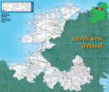
North West Ireland Tourism
Visitor Guide to Mayo, Sligo, Donegal, Roscommon, Leitrim, Cavan & Monaghan
Visitor Guide to Mayo, Sligo, Donegal, Roscommon, Leitrim, Cavan & Monaghan
The Achill Scenic Drive
| 0-9 A B C D E F G H I J K L M N O P Q R S T U V W X Y Z |
The Achill Scenic Drive
Westport - Newport - Mulranny - Achill Sound - Dooega - Keel - Dooagh - Keem Bay - Dugort (121km / 76mls - Detour 22km / 14mls)
Leave Westport on the N59 road for Newport. On the right, 1km outside town , is a monument commemorating a major event in Irish History. It was here, in June 1879, that the Irish Land League, an organisation established to protect tenant farmers, had its most important meeting, which was addressed by the League's two leaders, Charles Stewart Parnell and Michael Davitt.
As you enter Newport, just before you cross the river, you will find details of a fine walking trail leading from Newport to Bangor. On the right, is a seven arch viaduct which was erected in 1892 to connect the Westport to Achill Railway line.
After Newport, take the Achill Road. You will come quickly to a sign on the right, leading to the Nephin Drive. A series of lakes and mountains provide a very scenic drive, and on this road, too, is a Salmon Research Fishing Agency Centre where a visitor centre, tells the story of salmon, and is open during the summer.
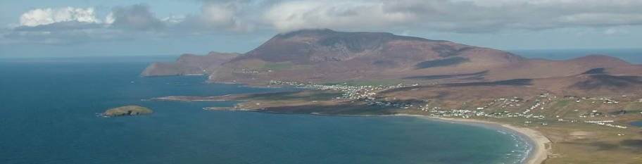
Return to the main road, and as you approach Achill, you will see a sign to the left for Burrishoole Abbey (1 km), the ruin of a 15th century Dominican Friary, which is of historic interest. On the main road drive towards Mulranny, a lush area, leading to Achill Sound and Achill, Ireland's largest island (24 km long and 19 km wide), now connected to the mainland by a bridge. Magnificent cliff scenery, long sandy beaches, little villages and masses of historical monuments make the island a must for anybody who appreciates beauty and culture.
At Achill Sound follow the Main road to Keel, or take the scenic Atlantic drive along the south of the island. It is a stunning drive, but it is not for the unsure driver.
The Atlantic Drive will bring you past the ancient Church of Kildavnet, which translates as the Church of St Dympna. Dympna fled to Achill to escape her fathers incestuous demands and founded a church. To your left is Granuaile's Castle, once a watchtower for the famous 16th century pirate queen.
Continue to the new pier where there is a monument to 32 people who drowned in Clew Bay in 1894. Be prepared for some tremendous scenery as you drive around the coast to Dooega.
Keel, a delightful village, has a 5 km sand beach known as Trawmore. At the end of the beach the Monawn Cliffs and the Cathedral rocks are a remarkable sight. Three km beyond Keel is the village of Doonagh. Keem Bay, 5km west of this is a glorious inlet with another fine sandy beach. To the north and west is the quartzite peak of Croaghaun washed by the Atlantic. If you are mountain climbing, it is not safe To go near the edge, as Croaghaun drops suddenly to the ocean at its highest point. Achill Head dominates this area.
Dugort, at the foot of the Slievemore Mountains on Achill's north Shore, is another popular village. At the back of Slievemore Mountain the Atlantic has carved out little islands and caves. Seals bask here in hot summer days.
At the eastern base of the mountain between Dugort and Keel is the site of the old village of Slievemore. If you want to climb here, more superb scenery such as megalithic tombs and other pre-historic monuments will be you reward. Further east, there is a beach at Poulavaddy. After exploring Achill, you may decide to stay overnight and sample the pubs and restaurants on the island.
(A) Westport | (B) Newport | (C) Mulranny | (D) Achill Sound | (E) Dooega | (F) Keel | (G) Dooagh / Keem Bay | (H) Dugort
Leave Westport on the N59 road for Newport. On the right, 1km outside town , is a monument commemorating a major event in Irish History. It was here, in June 1879, that the Irish Land League, an organisation established to protect tenant farmers, had its most important meeting, which was addressed by the League's two leaders, Charles Stewart Parnell and Michael Davitt.
As you enter Newport, just before you cross the river, you will find details of a fine walking trail leading from Newport to Bangor. On the right, is a seven arch viaduct which was erected in 1892 to connect the Westport to Achill Railway line.
After Newport, take the Achill Road. You will come quickly to a sign on the right, leading to the Nephin Drive. A series of lakes and mountains provide a very scenic drive, and on this road, too, is a Salmon Research Fishing Agency Centre where a visitor centre, tells the story of salmon, and is open during the summer.
Return to the main road, and as you approach Achill, you will see a sign to the left for Burrishoole Abbey (1 km), the ruin of a 15th century Dominican Friary, which is of historic interest. On the main road drive towards Mulranny, a lush area, leading to Achill Sound and Achill, Ireland's largest island (24 km long and 19 km wide), now connected to the mainland by a bridge. Magnificent cliff scenery, long sandy beaches, little villages and masses of historical monuments make the island a must for anybody who appreciates beauty and culture.
At Achill Sound follow the Main road to Keel, or take the scenic Atlantic drive along the south of the island. It is a stunning drive, but it is not for the unsure driver.
The Atlantic Drive will bring you past the ancient Church of Kildavnet, which translates as the Church of St Dympna. Dympna fled to Achill to escape her fathers incestuous demands and founded a church. To your left is Granuaile's Castle, once a watchtower for the famous 16th century pirate queen.
Continue to the new pier where there is a monument to 32 people who drowned in Clew Bay in 1894. Be prepared for some tremendous scenery as you drive around the coast to Dooega.
Keel, a delightful village, has a 5 km sand beach known as Trawmore. At the end of the beach the Monawn Cliffs and the Cathedral rocks are a remarkable sight. Three km beyond Keel is the village of Doonagh. Keem Bay, 5km west of this is a glorious inlet with another fine sandy beach. To the north and west is the quartzite peak of Croaghaun washed by the Atlantic. If you are mountain climbing, it is not safe To go near the edge, as Croaghaun drops suddenly to the ocean at its highest point. Achill Head dominates this area.
Dugort, at the foot of the Slievemore Mountains on Achill's north Shore, is another popular village. At the back of Slievemore Mountain the Atlantic has carved out little islands and caves. Seals bask here in hot summer days.
At the eastern base of the mountain between Dugort and Keel is the site of the old village of Slievemore. If you want to climb here, more superb scenery such as megalithic tombs and other pre-historic monuments will be you reward. Further east, there is a beach at Poulavaddy. After exploring Achill, you may decide to stay overnight and sample the pubs and restaurants on the island.
(A) Westport | (B) Newport | (C) Mulranny | (D) Achill Sound | (E) Dooega | (F) Keel | (G) Dooagh / Keem Bay | (H) Dugort