
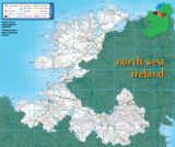
North West Ireland Tourism
Visitor Guide to Mayo, Sligo, Donegal, Roscommon, Leitrim, Cavan & Monaghan
Visitor Guide to Mayo, Sligo, Donegal, Roscommon, Leitrim, Cavan & Monaghan
The North Mayo Drive
| 0-9 A B C D E F G H I J K L M N O P Q R S T U V W X Y Z |
The North Mayo Drive
Ballina - Killala - Ballycastle - Belderg - Barnatra - Belmullet - Mullet Peninsula - Belmullet - Bangor - Crossmolina - Ballina (173 km / 108mls)
Leave Ballina, going north towards Killala. Along the way, you will pass near Kilmoremoy where a church was founded by St. Patrick's disciple, Olcan. St. Patrick is also said to have founded a church in Killala, which is assigned to one of his disciples, St Muredach. This area is rich in archaeological remains and ecclesiastical monuments. Killala featured strongly in the 1788 Rising, and was taken by the Franco-Irish force of General Humbert. Killala is also a well known angling centre. Take the road for Ballycastle, and after crossing Palmerstown Bridge, you can detour to Kilcummin Strand on you right, where General Humbert and his French force landed in 1798. Return to the route and visit Ballycastle. Next, you'll come to the Ceide Fields, the world's most extensive Stone Age site, 8km west of Ballycastle.
The 1500 hectare archaeological site, dating back some 5,000 years and preserved under blanket bog, features stone walls, field-systems, enclosures, and stone Age tombs. The Ceide Fields Visitors' Centre explains the geology, archaeology, botany wildlife of North Mayo. Near the Centre the road runs close to the magnificent cliffs of Ceide, made up of hundreds of layers of rock, built up over millions of years. After visiting the Ceide Fields continue on the road to Belmullet. On your left is blanket bog, while to the right is Belderrig prehistoric farm. You can, if you wish, turn right at Glenamoy Bridge for a tour to a Portacloy and Carrowtigue, 13 km away. This harbour, set between high cliffs, has some terrific coastal scenery, and lovely walks. The Stags of Broad Haven rise from the Atlantic just off the shore, reaching a height of 91 meters. Returning to Glenamoy, continue towards Belmullet. Soon you will reach a sign for Pulathomas to the right. This road travels around a scenic peninsula, rich in archaeological remains. Return to the main road at Barnatra and turn right to Bellmullet, the gateway to the Mullet Peninsula, built on a narrow neck of land between Broad Haven and Blacksod Bays.
The Mullet Peninsula offers visitors splendid scenery: beaches, cliffs, calm bays and raging seas. It has many species of fish and is also rich in bird life, and in legend. According to Irish Mythology, the four children of Lir were changed into swans by their evil stepmother and condemned to spend 900 years on various Irish Lakes and seas before arriving at their final resting place at Erris. When you have explored the Mullet Peninsula take the R313 to Bangor. Continue driving towards Ballina, with the Nephin Beg mountain range in sight, and the Owenmore River on the right. On the way you will pass the ESB Power station and 21 mills of commercial windmill farm, set up in 1922. Here, during the summer months, you can take a trip on a narrow gauge railway through the vast bogland area, and even try your hand at cutting turf. Turn left for Crossmolina, passing the Bord na Mona works on your left. Further along the road, on your right is Carowkilleen Court tomb. From here, return to Ballina.